Bowle's New Pocket map of the United States of America :...


 Maps, plans and nautical charts
Bowle's New Pocket map of the United States of America : British Possessions of Canadá, Nova Scotia, and... (1784)
Maps, plans and nautical charts
Bowle's New Pocket map of the United States of America : British Possessions of Canadá, Nova Scotia, and... (1784)
 Disponible Holdings
 Section: Maps, plans and nautical charts
Uniform title: Estados Unidos. Colonias. 1784 (1783). 1:6595697
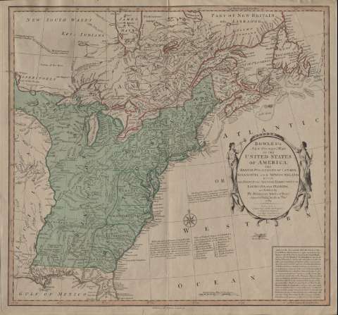
Title: Bowle's New Pocket map of the United States of America : British Possessions of Canadá, Nova Scotia, and Newfoundland with the french and spanish territories of Louisiana and Florida, as settled by the Preliminary Articles of Peace, signed at Versailles the 20 th Jany. 1783
Material or type of resouce Area: Escala [ca. 1:6.595.697] ( (O 93°00'-O 51°41'/N 50°50'-N 29°30')
Publication: London : Carington Bowles, 1784
Physical description: 1 mapa : col. ; 46 x 50 cm
Content type: Imagen cartográfica
Media type: computadora
Carrier type: recurso en línea
Notes: Escala gráfica en 250 millas inglesas [= 6,1 cm]. Coordenadas referidas al meridiano de Ferro
Título inscrito en óvalo entre dos figuras alegóricas de la paz
Materia / lugar / evento: Colonias
Estados Unidos
Other authors: Bowles, Carrington, 1724-1793
UDC: 73-11
Type of publication:
Maps
Rights:
Préstamo:
Disponible
