An Accurate Map of North and South Carolina with Their...


 Maps, plans and nautical charts
An Accurate Map of North and South Carolina with Their Indian Frontiers : Shewing in a diftinet manner all the... (1794)
Maps, plans and nautical charts
An Accurate Map of North and South Carolina with Their Indian Frontiers : Shewing in a diftinet manner all the... (1794)
 Disponible Holdings
 Section: Maps, plans and nautical charts
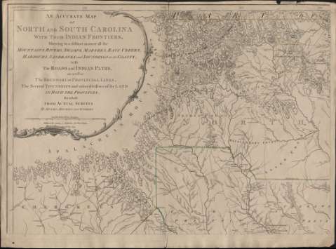
Title: An Accurate Map of North and South Carolina with Their Indian Frontiers : Shewing in a diftinet manner all the Mountains, Rivers, Swamps, Marshes, Bays, Creeks, Harbours, Sandbanks and Soundings on the Coasts , with the Roads and Indian Paths , as well as the Boundary or Provincial Lines, The Several Townships and other divisions of the Land in Both the Provinces ; the whole From Actual Surveys / by Henry Mouzon and Others
Material or type of resouce Area: Escala [ca. 1:551.777], 60 english miles 69 1/2 to a degree [=17'5 cm]
Publication: [London] : Laurie & Whittle, 1794
Physical description: 1 mapa en 4 h. : col. ; h. de 50 x 70 cm cada una
Content type: Imagen cartográfica
Media type: computadora
Carrier type: recurso en línea
Notes: Coordenadas referidas al meridiano de Londres (O 33°55'-O 75°45'/N 36°37'-N 31°54'). Orientado con media flecha. Indica ángulo de declinación magnética
Relieve representado por normales
Indica veriles, bajos, fondeaderos y sondas batimétricas
Señala dirección de las corrientes mediane flechasm líneas de derrota, etc.
Representación de distintos tipos de embarcaciones en el océano
Título enmarcado por una orla con greca
Inserta: The Harbour of Port Royal. - Escala [ca. 1:231000], 4 millas inglesas [=3'2 cm]. The Bar and Harbour of Charlestown. - Escala [ca. 1:87000], 3 millas inglesas [=6'4 cm]
Materia / lugar / evento: Mapas generales
Carolina del Sur
Estados Unidos
Other authors: Mouzon, Henry, 1741-1807
Robert Laurie and James Whittle
UDC: 756
Type of publication:
Maps
Rights:
Préstamo:
Disponible
