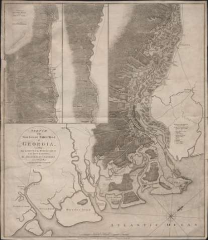
Sketch of the Northern Frontiers of Georgia extending...


 Maps, plans and nautical charts
Sketch of the Northern Frontiers of Georgia extending from the Mout of the River Savannah to the Town of Augusta (1780)
Maps, plans and nautical charts
Sketch of the Northern Frontiers of Georgia extending from the Mout of the River Savannah to the Town of Augusta (1780)
 Disponible Holdings
 Section: Maps, plans and nautical charts
Title: Sketch of the Northern Frontiers of Georgia extending from the Mout of the River Savannah to the Town of Augusta / by Archibald Campbell Lieutt. Colt. 71 st. Regt. ; Engraved by Willm. Faden Charing Cross 1780
Material or type of resouce Area: Escala [ca. 1:110.989], 10 statute miles [= 14,5 cm]
Publication: London : Published as the Act directs by Wm. Faden corner of St. Martins Lane Charing Cross, 1780
Physical description: 1 mapa ; 70 x 60 cm
Content type: Imagen cartográfica
Media type: computadora
Carrier type: recurso en línea
Notes: Orientado con lis en rosa de 16 vientos prolongados
Indica sondas batimétricas
Señala cultivos, masas forestales, carreteras, núcleos de población, etc.
Nota relativa al ataque de Savannah el 28 de diciembre de 1778
Inserta: "Continuation of Savanna River, from Ebenezer to Augusta". Escala en millas, se desconocen las unidades
Materia / lugar / evento: Mapas generales
Savannah
Georgia (Estados Unidos)
Other authors: Campbell, Archibald Sir
Faden, William, 1749-1836
UDC: 758
Type of publication:
Maps
Rights:
Préstamo:
Disponible
