Plan of the Posts of York and Gloucester in the Province...


 Maps, plans and nautical charts
Plan of the Posts of York and Gloucester in the Province of Virginia : Established by His Majesty's Army under the... (1782)
Maps, plans and nautical charts
Plan of the Posts of York and Gloucester in the Province of Virginia : Established by His Majesty's Army under the... (1782)
 Disponible Holdings
 Section: Maps, plans and nautical charts
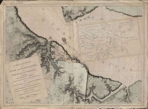
Title: Plan of the Posts of York and Gloucester in the Province of Virginia : Established by His Majesty's Army under the Command of Lieutt. General Earl Cornwallis, together with the Attacks and Operations of the Americans & French Forces Commanded by General Washington and the Count of Rochambeau, Which Terminated in the Surrender of the faid Pofts and Army on the 17th. of October 1781 / Surveyed by Captn. Fage of the Royal Artillery
Material or type of resouce Area: Escala [ca. 1:5.900], 3000 feet [= 15,6 cm]
Publication: [London] : [s.n.], 1782
Physical description: 1 mapa : col. ; 75 x 105 cm
Content type: Imagen cartográfica
Media type: computadora
Carrier type: recurso en línea
Notes: Orientado con lis en nudo de rumbos
Relieve representado por sombreado
Figuran representados los barcos Guadaloupe y Charon atacados por los franceses
Señala las posiciones de los ejércitos el 28 y 29 de septiembre de 1781 en papel volante y cultivos, masas forestales, fortificaciones, carreteras, etc.
Indica las posiciones de los ejércitos francés y americano por clave numérica
Inserta: Chesapeak Bay. - Escala [ca. 1:275000], 12 millas [= 8,1 cm]
Materia / lugar / evento: Operaciones bélicas
Gloucester (Estados Unidos)
Virginia
Other authors: Fage, Edward
UDC: 755 Yorktown
Type of publication:
Maps
Rights:
Préstamo:
Disponible
