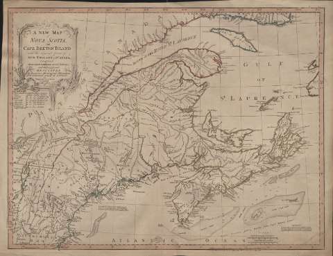
A New Map of Nova Scotia and Cape Breton Island : with...
Section: Maps, plans and nautical charts
Uniform title: NUEVA ESCOCIA (Canadá). Mapas generales. 1:1900000 (1786)
Title: A New Map of Nova Scotia and Cape Breton Island : with the adjacent parts of New England and Canadá : Composed from a great number of actual Surveys and other materials... / by Thomas Jefferys
Material or type of resouce Area: Escala [ca. 1:1.900.000] ( (O 91°39'46''-O 75°39'46''/N 49°50'00''-N 42°40'00''), english marine leagues [= 5,8 cm])
Publication: London : Published according to Act of Parliament by thos. Jefferys..., 1786 (London: Printed & Sold by R. Sayer Map-seller N. 53 in Fleet street, 1 Augt. 1786)
Physical description: 1 mapa : col. ; 47 x 61 cm
Content type: Imagen cartográfica
Media type: computadora
Carrier type: recurso en línea
Notes: Presenta Nueva Escocia y territorios limítrofes, con líneas divisorias en varios colores
Escala gráfica de 70 millas inglesas [= 5,8 cm]. Coordenadas referidas al meridiano de Hierro (O 91º39'-O 75º39'/N 49º50'-N 42º40'). Red geográfica de 1º en 1º
Indica veriles, bajos y sondas batimétricas
Notas explicativas con datos geográficos e históricos de interés, y relación de algunos puntos del documento sobre su situación en grados
Título enmarcado en cartela profusamente decorada
Materia / lugar / evento: Mapas generales
Nueva Escocia
Canadá
Other authors: Jefferys, Thomas, ca. 1710-1771
Sayer, Robert, 1725-1794
UDC: 716
Type of publication:
![]() Maps
Maps
Préstamo:
![]() Disponible
Disponible


