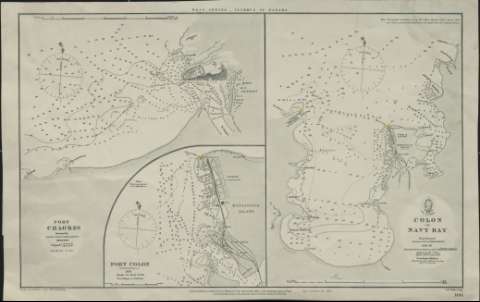
Colon or Navy Bay


Section: Maps, plans and nautical charts
Uniform title: COLON (Panamá). Bahías. 1882. 1:48733 (1829-1840)
Title: Colon or Navy Bay / From Surveys by Major Lloyd & Commª Barnett 1829-40 ; Additions by Mr. J. Waye
Edición: Large corrections Oct. 1882
Material or type of resouce Area: Escala [ca. 1:48.733]. 10 cables [= 3,8 cm]
Publication: London : Published according to Act of Parliament at the Hydrographic Office of the Admiralty August 23th., Sold by J.D. Potter, Agent for the Admiralty, Charts, 31 Poultry & 11 King Str. Tower Hill, 1882
Physical description: 1 carta náutica ; 27 x 19 cm en h. de 29 x 46 cm
Content type: Imagen cartográfica
Media type: computadora
Carrier type: recurso en línea
Notes: Escala también expresada en 3 millas marinas [= 11,4 cm]
Incluye los mapas de Puerto Chagres y el Puerto Colón (Aspinwall)
Orientado con diagrama de variación magnética, rosa y lis
Abundancia de datos de sondeo batimétrico y nota en la que se aclara que es una corrección respecto al levantamiento original. Localizados, en rojo y amarillo, los faros de la Bahía
Título en el margen superior: "West Indies, Isthmus of Panama"
Materia / lugar / evento: Cartas náuticas
Manzanillo (Panamá; bahía)
Colón (Provincia)
Genre / form: Cartas náuticas
Other authors: Barnett, E
Potter, J.D
Waye, J
Lloyd, Major
Gran Bretaña. Admiralty
UDC: 912:551.46(728.7)"1829-1840"
728.7
Type of publication:
 Maps
Maps
Rights:
Préstamo:
 Disponible
