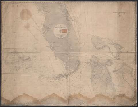
The Bahama bank and Gulf of Florida


Section: Maps, plans and nautical charts
Uniform title: FLORIDA (Estrecho). Cartas náuticas (1868-1869). 1:795000
Title: The Bahama bank and Gulf of Florida / Hydrograhic Office
Material or type of resouce Area: Escala [ca. 1:750.000] ; [proy. Mercator] ( (O 85°50'--O 76°00'/N 29°38'--N 22°45')
Publication: Wanshigton : Hydrographic Office, 1869
Physical description: 1 carta náutica : montada sobre tela ; 97 x 126 cm
Content type: Imagen cartográfica
Media type: computadora
Carrier type: recurso en línea
Notes: Presenta el litoral marítimo de las Islas Bahamas y el Golfo de Florida
Orientado con lis. Figura gráfico de declinación magnética
Representación de números de sonda, isolíneas batimétricas, y grados de declinación, así como señalización de corrientes mediante flechas
Mapa en dos hojas unido en tela, hoja no. 1 publicada en 1868 (No. 19) y hoja No. 2 publicada en 1869 (No. 20) cada una con el mísmo título y mención de responsabilidad
Inserta : Key-West Harbor / by J. R. Rodgers, 1851. Con escala en 4 millas náuticas de [ca. 1:123000]
Ex libris de T. S. Negus & co. y precio
Other authors: Estados Unidos. Hydrographic Office
UDC: 759
Type of publication:
 Maps
Maps
Rights:
Préstamo:
 Disponible
