The Island of St. John : divided into Counties and...


 Maps, plans and nautical charts
The Island of St. John : divided into Counties and Parishes with the Lots as granted by Goverment exhibiting all the... (1789)
Maps, plans and nautical charts
The Island of St. John : divided into Counties and Parishes with the Lots as granted by Goverment exhibiting all the... (1789)
 Disponible Holdings
 Section: Maps, plans and nautical charts
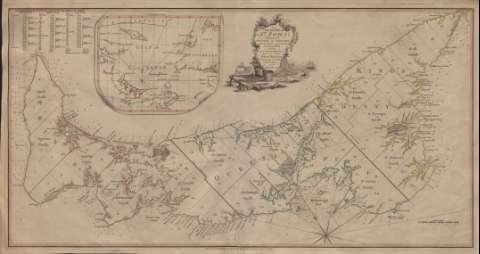
Title: The Island of St. John : divided into Counties and Parishes with the Lots as granted by Goverment exhibiting all the New Settlements / By Major Holland Surveyor Genl. of Canada and its Dependencies
Material or type of resouce Area: Escala [ca. 1:303.582]
Publication: [London], Charing Cross : Pusblished by W. Faden, Geogr. to the King, 1789
Physical description: 1 mapa : col. ; 37 x 71 cm
Content type: Imagen cartográfica
Media type: computadora
Carrier type: recurso en línea
Notes: Título y autor comprendidos en un grabado decorativo
Escala gráfica en millas supuestamente marinas inglesas
Indica latitud : 46° 30'
Orientada con rosa de ocho vientos y lis
En tinta amarilla, roja y verde sólo el borde costero y divisiones administrativas
En el ángulo superior izquierdo, índice del número de ciudades y extensión en acres de cada división administrativa de la isla
Indica la batimetría de la costa
Inserta : Mapa del Golfo de San Lorenzo. Longitud del meridiano de Londres. Coordenadas: (O 65°--O 56°/N 50°--N 56°) Orientado con nudo de rumbos y lis. Destacada en rojo la isla
Materia / lugar / evento: Parcelación
Divisiones administrativas
Príncipe Eduardo (Isla)
Other authors: Holland, Samuel
Faden, William, 1749-1836
UDC: 912:332.22.055.64:801.311(3)(717-2/-5)"1789"
717-2/-5
Type of publication:
Maps
Rights:
Préstamo:
Disponible
