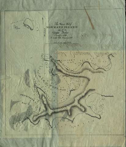
The Western Part of Normans Island one of the Virgin...


 Maps, plans and nautical charts
The Western Part of Normans Island one of the Virgin Ysles : surveyd in 1789 (1789)
Maps, plans and nautical charts
The Western Part of Normans Island one of the Virgin Ysles : surveyd in 1789 (1789)
 Disponible Holdings
 Section: Maps, plans and nautical charts
Title: The Western Part of Normans Island one of the Virgin Ysles : surveyd in 1789 / by [sic.] Lieut. E.H. Columbine, R.N. [Royal Navy].
Material or type of resouce Area: Escala [ca. 1:31.400]. 1/2 an English Miles
Publication: 1789
Physical description: 1 carta náutica : ms. ; 27,1 x 23,2 cm
Content type: Imagen cartográfica
Media type: computadora
Carrier type: recurso en línea
Notes: Presenta todas las bahías que aparecen en el lado oeste de la Isla
Relieve representado por sombreado y montes de perfil
Indica sondas batimétricas y bajos
Orientado con media lis y mención del grado de declinación magnética
Escala gráfica en millas
Materia / lugar / evento: Cartas náuticas
Islas Vírgenes
Genre / form: Manuscritos
Other authors: Columbine, E. H
UDC: 912:551.46]:627.231(729.71/72)"1789"
729.71/72 Normans, Isla
Type of publication:
Maps
Rights:
Préstamo:
Disponible
