Carta Telegráfica de España y Portugal


 Maps, plans and nautical charts
Carta Telegráfica de España y Portugal (1861)
- Mathé, José María, 1800-1875
Maps, plans and nautical charts
Carta Telegráfica de España y Portugal (1861)
- Mathé, José María, 1800-1875
 Disponible Holdings
 Section: Maps, plans and nautical charts
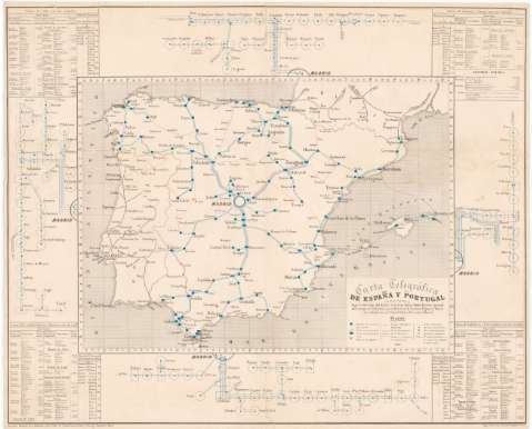
Title: Carta Telegráfica de España y Portugal / compuesta bajo la direccion del Exmo. Sr. D. José Maria Mathé Director general del cuerpo de Telégrafos por el Director de Sección D. Ygnacio Hacar y los Subdirectores D. Rafael Palet y D. Vicente Villareal
Author: Mathé, José María, 1800-1875
[Carta Telegráfica de España y Portugal] All editions
Characteristics of the edition: 1861. 1:2.000.000. Español
Material or type of resouce Area: Escala [ca. 1:2.000.000 ; proy. Mercator]
Publication: Paris : Librairie Militaire de J. Dumaine Librre. Editr. de l'Empereur, 30 Rue et Passage Dauphine, 1861 (Imp. Lith. Goyer, Passage Dauphine 7)
Physical description: 1 mapa : grab., col., montado sobre tela ; 69 x 86 cm
Content type: Imagen cartográfica
Media type: computadora
Carrier type: recurso en línea
Notes: Escala hallada a partir de un grado de latitud [= 5,4 cm]. Coordenadas referidas al meridiano de Cádiz (O 3°51'--E 11°15'/N 44°03'--N 35°41'). Red geográfica de 1° en 1°
Tabla de signos convencionales para indicar estaciones de servicio de diferente categoría, líneas telegráficas españolas, francesas y portuguesas, líneas en proyecto y en construcción, cables submarinos y aparatos telegráficos de distinta clase
En los márgenes figuran cuatro esquemas con las líneas telegráficas radicales indicando el número de alambres de cada sección
Inserta: "Linea de Irún con sus ramales", "Lineas de Valencia y Cuenca con sus ramales", "Lineas de Castilla, Galicia y Asturias con sus ramales" y "Lineas de Andalucia y Estremadura con sus ramales". Se especifica las direcciones y distancia entre las estaciones y la recaudación anual, con las clases y números de material y personal
Genre / form: Mapas temáticos
Other authors: Hacar, Ignacio
Palet, Rafael
Villareal, Vicente
Librairie militaire de J. Dumaine
Imprimerie Lithographie Goyer (París)
UDC: 912:621.394.6(460)(469)(44-14)"1861"
(460)
(469)
(44-14)
Type of publication:
Maps
Rights:
Préstamo:
Disponible
