Cantabria


Section: Maps, plans and nautical charts
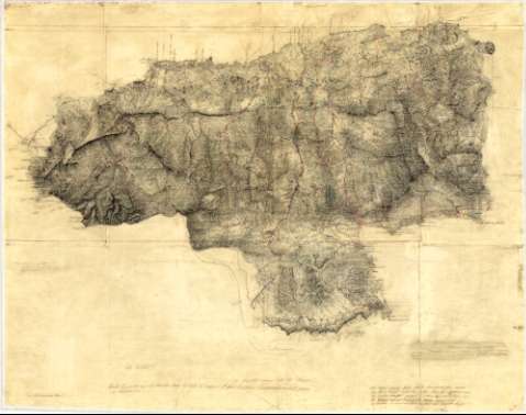
Uniform title: Santander. Mapas generales. Español (1860?). 1:200.000
Title: Cantabria / [Francisco Coello]
Material or type of resouce Area: Escala [1:200.000] ; [proy. de Bonne]
Publication: [1860?]
Physical description: 1 mapa : ms., col., montado sobre tela ; 52,7 x 67,3 cm
Content type: Imagen cartográfica
Media type: computadora
Carrier type: recurso en línea
Notes: Se trata de la minuta original de la edición de 1861 del mapa de signatura SG. Ar.E-T.5-C.2-27. Coordenadas referidas al meridiano de Madrid (O 1°28'--E 0°54'/N 43°30'--N 42°23'). Red geogáfica de 30' en 30'
Escala tomada del documento de signatura SG. Ar.E-T.5-C.2-27
Orografía por curvas de configuración y puntos acotados, expresados en pies castellanos
Indica sondas batimétricas en brazas y pies de Burgos, veriles y bajos en algunos puntos de la costa
Señala mediante signos convencionales, aún cuando no figure la correspondiente tabla, núcleos de población de distinta categoría, fortificaciones, capillas, conventos, molinos, telégrafos, principales accidentes geográficos y límites administrativos (provincias, partidos, términos municipales y obispados)
Constan varias notas del autor en las que apunta consejos y advertencias para la grabación del documento y otras en las que se indican los signos covencionales utilizados para diferenciar líneas ferroviarias construidas y en proyecto, y carreteras
Materia / lugar / evento: Mapas generales
Costas
Puertos
Divisiones administrativas
1860
Cantabria (Comunidad Autónoma)
Genre / form: Mapas generales
Manuscritos
Other authors: Coello, Francisco, 1822-1898
UDC: 912:(1-2/-5)(463.3)"1860"
463.3
Type of publication:
 Maps
Maps
Rights:
Préstamo:
 Disponible
