[Kabilas ribereñas del Uarga]


Section: Maps, plans and nautical charts
Uniform title: Rif (Región histórica). S. Establecimientos militares. 1916-1930. Español. 1:200.000
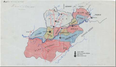
Title: [Kabilas ribereñas del Uarga]
Material or type of resouce Area: Escala 1:200.000
Publication: [1916-1930?]
Physical description: 1 mapa : ms., col., sobre tela para planos ; 28 x 48 cm
Content type: Imagen cartográfica
Media type: computadora
Carrier type: recurso en línea
Notes: Comprende la parte S. de la región del Rif, junto al curso del río Uarga, abarcando las cabilas de Beni Ahmed, Beni Buchibet y Beni Bechir
Orientado con flecha
Clave de signos convencionales representando los asentamientos militares
Fecha aproximada de ejecución deducida de la creación de la Delegación de Asuntos Indígenas cuyos puestos se representan en el mapa
Manuscrito a plumilla en tintas negra, azul y carmín, coloreado
Materia / lugar / evento: Establecimientos militares
Divisiones administrativas
1916
1930
Uarga (Río)
Beni Ahmed
Beni Bechir
Beni Buchibet
Rif (Región histórica)
Marruecos
UDC: (64 Rif, S.)
Type of publication:
 Maps
Maps
Rights:
Préstamo:
 Disponible
