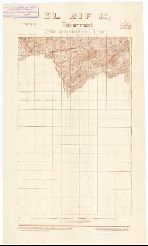
Tabarrant : El Rif. H. 16-8


 Maps, plans and nautical charts
Tabarrant : El Rif (1946)
- España. Servicio Geográfico del Ejército
Maps, plans and nautical charts
Tabarrant : El Rif (1946)
- España. Servicio Geográfico del Ejército
 Disponible Holdings
 Section: Maps, plans and nautical charts
Title: Tabarrant : El Rif. H. 16-8
Material or type of resouce Area: Escala 1:50.000
Publication: [Madrid] : Talleres del Servicio Geográfico del Ejercito, 1946
Physical description: 1 h. : montado sobre tela ; 54 x 32 cm
Content type: Imagen cartográfica
Media type: computadora
Carrier type: recurso en línea
Notes: En margen superior: Gráfico de localización de la hoja
Márgenes inferior y derecho graduados. - Mapa en cuadrícula. - Relieve representado por curvas de nivel, equidistancia 20 metros y puntos acotados. - Arbolado. - Hidrografía. - Red de caminos. - Toponimia. - Representación de núcleos urbanos, edificaciones aisladas y santuarios. - Divisiones administrativas
No comprende la totalidad del terreno que pertenece al Protectorado Español, a causa de no haberse podido realizar con anterioridad a la fecha de su publicación, las operaciones topográficas para la delimitación de las zonas Española y Francesa
Other titles: En: Marruecos : Mapa provisional en E. 1:50.000. - 2ª ed.. - [Madrid] : Servicio Geográfico del Ejército, 1934-1953. - H. 16-8
Materia / lugar / evento: Marruecos - Historia - 1912-1956 (Protectorado español) - Mapas
Tabarrant (Marruecos, Río) - Mapas
Genre / form: Mapas topográficos
UDC: (64 El Rif)
Type of publication:
Maps
Rights:
Préstamo:
Disponible
