The Bay and Piers of Saint Sebastian


 Maps, plans and nautical charts
The Bay and Piers of Saint Sebastian
- Tofiño de San Miguel, Vicente, 1732-1795
Maps, plans and nautical charts
The Bay and Piers of Saint Sebastian
- Tofiño de San Miguel, Vicente, 1732-1795
 Disponible Holdings
 Section: Maps, plans and nautical charts
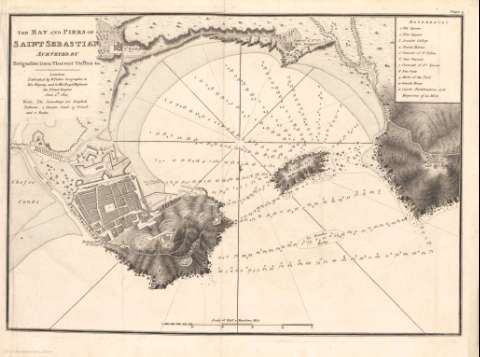
Title: The Bay and Piers of Saint Sebastian / Surveyed by Brigadier Don Vincent Tofiño
Material or type of resouce Area: Escala [ca.1:6.313]. 0,5 Maritime Mile [= 11 cm]
Physical description: 1 carta náutica ; 27 x 35 cm
Content type: Imagen cartográfica
Media type: computadora
Carrier type: recurso en línea
Notes: Orientado con media flor de lis en nudo de rumbos
Indica sondas, bajos y veriles
Relieve por normales y sombreado
Plano de la ciudad
Clave numérica para indicar los edificios y lugares más significativos
Clave alfabética para indicar la calidad del fondo
Copia digital. Madrid : Ministerio de Cultura, 2010
Materia / lugar / evento: Cartas náuticas
Planos
Puertos
Bahías
Costas
Núcleos de población
Accidentes geográficos
1812
San Sebastián
España
Related titles: SAN SEBASTIÁN (Guipúzcoa) (Bahía). Cartas náuticas. 1:6.313 (1812)
UDC: (460)
Type of publication:
Maps
Préstamo:
 Disponible sólo para consulta en sala
