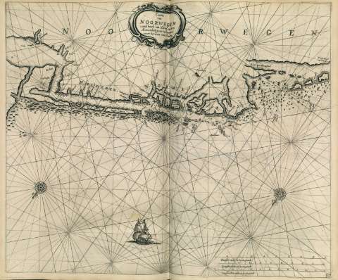
Caarte van Noorwelgen vande hoeck van Horrel tot aen...


 Maps, plans and nautical charts
Caarte van Noorwelgen vande hoeck van Horrel tot aen Momendael waer in gegrepen wort het Liet van Dronten (1669)
Maps, plans and nautical charts
Caarte van Noorwelgen vande hoeck van Horrel tot aen Momendael waer in gegrepen wort het Liet van Dronten (1669)
 Disponible Holdings
 Section: Maps, plans and nautical charts
Uniform title: Noruega. Cartas náuticas. 1669. 1:380000
Title: Caarte van Noorwelgen vande hoeck van Horrel tot aen Momendael waer in gegrepen wort het Liet van Dronten
Material or type of resouce Area: Escala [ca. 1:380000]
Publication, Production, Distribution, etc.: Producción: [Holanda], [1669]
Physical description: 1 carta náutica : grab. ; 43 x 53 cm
Content type: Imagen cartográfica
Media type: computadora
Carrier type: recurso en línea
Notes: Escalas gráficas de 12 millas inglesas y francesas de 20 al grado [= 17,7 cm], 10 millas españolas de 17 1/2 al grado [= 16,8 cm] y 9 millas holandesas de 15 al grado [= 17,7 cm]
Orientado con lis en dos rosas de treinta y dos vientos
Relieve de perfil y sombreado
Carta de araña en la que se indican bancos de arena y fondeaderos
Toponimia costera de los principales accidentes geográficos y núcleos de población
En el ángulo inferiror derecho : "12"
Título enmarcado en cartela barroca
Decorado con la figura de un galeón
Copia digital. Madrid : Ministerio de Cultura, 2010
Other titles: En: Le Grand et Nouveau Miroir de la Mer. - [Amsterdam] : Pieter Goss, [1669]. - [Mapa 42]
Materia / lugar / evento: Cartas náuticas
UDC: 912:551.46(481.7)"1669"
(481.7)
Type of publication:
Maps
Rights:
Préstamo:
 Disponible sólo para consulta en sala
