Sterlinensis Praefectura = Sterlin-Shyr


 Maps, plans and nautical charts
Sterlinensis Praefectura = Sterlin-Shyr (1654)
- Pont, Timothy, s. XVII
Maps, plans and nautical charts
Sterlinensis Praefectura = Sterlin-Shyr (1654)
- Pont, Timothy, s. XVII
 Disponible Holdings
 Section: Maps, plans and nautical charts
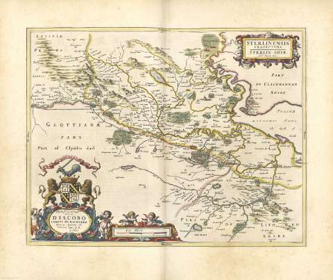
Title: Sterlinensis Praefectura = Sterlin-Shyr / Auct. Timoth. Pont
Author: Pont, Timothy, s. XVII
Other titles: Sterlin-Shyr
Material or type of resouce Area: Escala [ca. 1:960000]
Publication, Production, Distribution, etc.: Producción: [Holanda], [1654]
Physical description: 1 mapa : il., col. ; 41 x 52 cm
Content type: Imagen cartográfica
Media type: computadora
Carrier type: recurso en línea
Notes: Comprende la zona suroriental de la región Central desde Starling a Fakirk y desde el río Forth a Killsayth
Deddicatoria: "Illustrisssimo ac Nobilissimo Domino D. Iacobo Comiti de Kalender Domino Amonte etc. Tabulam hanc D. D."
Escala gráfica de 4 millas, habiéndose considerado para su cálculo la milla escocesa [= 9,3 cm]. Mención nominal de los puntos cardinales en los márgenes
Orientado
Límites de la provincia destacados con color
Dos cartelas, una doble conteniendo la dedicatoria y la escala, decorada con angelotes y coronado con un escudo nobiliario y otra conteniendo el título, adornada con motivos vegetales
Relieve por montes de perfil y sombreado
Hidrografía
Arbolado
Ciudades representadas
Costas sombreadas con un fino rayado
Toponimia
Copia digital. Madrid : Ministerio de Cultura, 2010
Other titles: En: Nuevo Atlas de los Reynos de Escocia e Yrlanda. - Amstelaedami : Apud Ioannem Blaeu, 1654. - [26]
Related titles: STERLING (Reino Unido). Mapas generales. 1654
UDC: 912:(1-2/-5)(411)"1654"
(413.6)
Type of publication:
Maps
Rights:
Préstamo:
 Disponible sólo para consulta en sala
