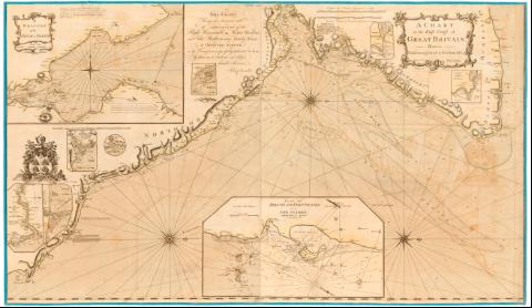
A chart of the East Coast of Great Britain between...


 Maps, plans and nautical charts
A chart of the East Coast of Great Britain between Flamborough head & Buchannefs, A] (1796)
Maps, plans and nautical charts
A chart of the East Coast of Great Britain between Flamborough head & Buchannefs, A] (1796)
 Disponible Holdings
 Section: Maps, plans and nautical charts
Uniform title: INGLATERRA (Reino Unido). NE. Cartas náuticas (1796). 1:330000
Title: A chart of the East Coast of Great Britain between Flamborough head & Buchannefs, A] / sclup Woodman & Mutliru ; By John Chandler and others experinced Pilots
Material or type of resouce Area: Escala [ca. 1:330000], 10 English and french leagues, 20 in a degree [= 17 cm]
Publication: London : Printed for David Steel, Bookeseller N. 1 Union Row, little toker Hill, 1796
Physical description: 1 carta nautica : col., montado sobre tela ; 75x130 cm, pleg en 66x76 cm
Notes: Dedicado : This Chant having been honoured with the Approbation of the Right Honourable the master : Woldeus and Eoden Brethien of the Trinity House of Deptford Strond...
Presenta ademas 8 mapas de detalle
Escala grafica de 7 millas germanas, alemanas y danesas, de 15 al grado [= 16 cm] Orientado con lis en rosa de 32 vientos prolongados
Relieve de perfil
Indica veriles, bajos, fondeaderos y sondas batimetricas
Tabla de signos convencionales para indicar bancos de arenas, dirección de las mareas, etc.
Materia / lugar / evento: Cartas náuticas
Costas
Cabos
1796
Flamborough (Cabo)
Northumberland
Other authors: Chandler, John
Steel, David
T. Woodman & H. Mutlow
UDC: 912:[551.46:551.468](410-328 Inglaterra)'1796'
(410 Flamborough)
(410 Northumberland)
Type of publication:
Maps
Rights:
Préstamo:
Disponible
