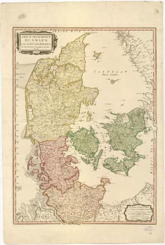
A Map of the Kingdom of Denmark with the Duchy of Holstein
Section: Maps, plans and nautical charts
Uniform title: Dinamarca. Mapas generales. 1:600000 (1790)
Title: A Map of the Kingdom of Denmark with the Duchy of Holstein / By William Faden...
Material or type of resouce Area: Escala [ca. 1:600000] 6 Common Danish leagues about 13 1/2 to a Degree [= 7,5 cm]
Publication: London : Printed for willm. Faden Charing Cross, 1790
Physical description: 1 mapa : col. ; 71x52 cm en h. de 87,3x58,5 cm
Notes: Comprende el estado alemán de Schleswig - Holstein
Escalas gráficas de 6 Swedish Statute leagues about 10 1/2 to a Degree, 8 German Miles 15 to a Degree, 35 British Statute Miles 69 1/2 to a Degree, 8 Nautic leagues 20 to a Degree. Coordenadas referidas al meridiano de Londres (E7#55'-E12#50'/N57#50'-N53#40'). Recuadro geográfico de 10' en 10'
Indica veriles y bajos
Tabla de signos convencionales para indicar carreteras de distinta categoria
Señala los limites administrativos en color amarillo, verde, rosa y marrón
Título y escalas enmarcados en cartela
Procede de la 'Colección Rico y Sinobas'
Materia / lugar / evento: Mapas generales
Divisiones administrativas
1790
Schleswig-Holstein
Other authors: Faden, William, 1749-1836
UDC: 912(489-2/-5)'1790'
(430-328 Schleswig-Holstein)
Type of publication:
![]() Maps
Maps
Préstamo:
![]() Disponible
Disponible
Préstamo:
![]() Disponible
Disponible


