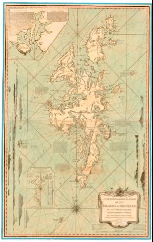
A new Hydrographical survey of the islands of Shetland


 Disponible Holdings
 Section: Maps, plans and nautical charts
Title: A new Hydrographical survey of the islands of Shetland / by Captn. Thomas Preston with many Improvements and Additions and The sailing Directions
Material or type of resouce Area: Escala [ca. 1:234000], 8 leagues [= 19 cm]
Publication: London : Printed for Robert Sayer N. 53, Fleet sheet, 1788
Physical description: 1 carta nautica : col., montado sobre tela ; 93x39 cm, pleg en 60,5x48 cm
Notes: Presenta además 7 perfiles
Orientado con lis en rosa de 32 vientos con angulo de declinación magneti
Indica veriles bajos, fondeaderos dirección de los mares con flecha Relieve de perfil sondas batimetricas Nota sobre 'The Coast of Shetland is high & Rocky & may be descried at a Great distance...' y en el mapa sobre los lugares mejores para pescar
Titulo enmarcado en cartela barroca
Inserta : The Isle of Feve. - Escala [ca. 1:176000]. Valey Island. - Escala [ca. 1:130000]
Mapa fraccionado
Other authors: Preston, Thomas
Sayer, Robert, 1725-1794
UDC: 912:[551.46:551.42:528.9](410 Shetland-islas)'1788'
410 Shetland- islas
Type of publication:
 Maps
Maps
Rights:
Préstamo:
Disponible
