A new plan of the City of London and borough of southwark...


 Maps, plans and nautical charts
A new plan of the City of London and borough of southwark, exibiting all the new streets, roads ; A new plan of the... (1766)
Maps, plans and nautical charts
A new plan of the City of London and borough of southwark, exibiting all the new streets, roads ; A new plan of the... (1766)
 Disponible Holdings
 Section: Maps, plans and nautical charts
Uniform title: LONDRES (Reino Unido). Planos de población. 1:8000 (1766)
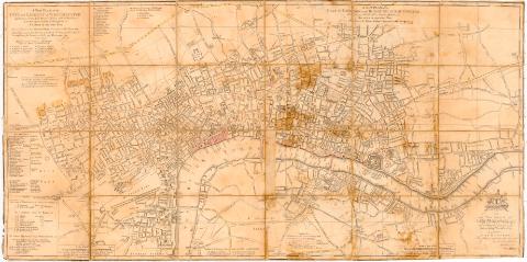
Title: A new plan of the City of London and borough of southwark, exibiting all the new streets, roads ; A new plan of the City and liberty of Westminster< : a new plan and liberty of Westminster Exhibiting all the new streets & Roads, with the Residences of the Principal nobility Public offices not extant in any other plan. This plans most humbly inscribed to the Rt. Honourable Fonble Commifsioners for Paving & the city of Westminster / Draw engraved by Thomas Jefferys. Geographer to his Majety
Material or type of resouce Area: Escala [ca. 1:8000] 4, half a mile [= 9 cm]
Publication: [Londres : s.n., 1766]
Physical description: 1 plano ; 46x92 cm, pleg en 23x46 cm
Notes: Dedicatoria : 'To the risht Honourable the Lord Manor Aldermeu and Commissioners of the severs Camps and Pavemeuls for The city of London'
Relación de los diversos distritos de Westmister y oficinas estatales indicados por clave alfabética y de autoridades de la zona y de las dependencias de la Torre de Londres
Nota sobre los colores empleados en los limites de distritos y barrios
En el ángulo inferior derecho escudo con leyenda 'Domine Dirige Nos'
Entelado en 24 cuarterones
Materia / lugar / evento: Planos de población
1766
Ciudad de Westminster
Other authors: Jefferys, Thomas, ca. 1710-1771
UDC: 912:314(410-328 Gran Londres)'1766'(084.3)
(410 Westminster)
Type of publication:
Maps
Rights:
Préstamo:
Disponible
