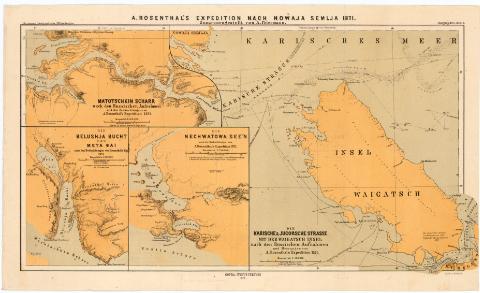
A. Rosenthal's expedition hach Nowaja Semlja 1871


 Disponible Holdings
 Section: Maps, plans and nautical charts
Title: A. Rosenthal's expedition hach Nowaja Semlja 1871 / Zusammengestellt von A. Petermann
Material or type of resouce Area: Varias escalas ; [proyec. cónica]
Publication: Gotha : Justus Perthes, 1872 (Gotha : Druck v. C. Hellfarth)
Physical description: 4 mapas en 1 h. : col. ; 28,1x46,8 cm en h. de 24,1x44, 9 cm
Notes: Pertenece a 'Petermann's Geographische Mittheilungen. Jahrgang 1872. Tafel 4'
Escalas gráficas en millas alemanas. Coordenadas referidas al meridiano de Greenwich
Relieve representado por normales. Sondas batimétricas
Indica derroteros con singladuras
Materia / lugar / evento: Expediciones geográficas
Derroteros
Islas
1871
Vaigach (Isla)
Other authors: Petermann, Augustus Herman
Perthes, Justus, 1749-1816
Hellfarth, C
UDC: 912:[656.02:527.6:551.42](47 Nueva Zembla, isla)'1871'
isla)
(47 Nueva Zembla, isla)
(47 Vajgac, isla)
Type of publication:
 Maps
Maps
Rights:
Préstamo:
Disponible
