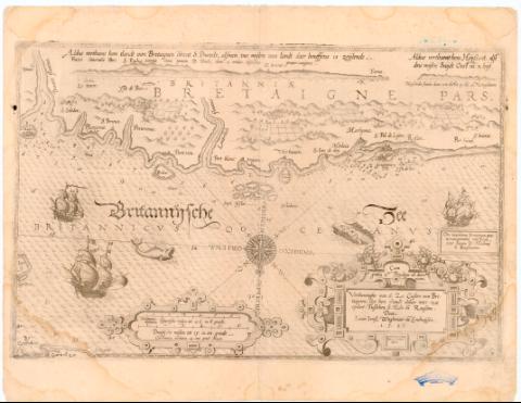
Verthoninghe van de Zee Cuften van Bretaigne ; Soe hem...


 Maps, plans and nautical charts
Verthoninghe van de Zee Cuften van Bretaigne ; Soe hem Thlandt oldaer noter zee opdiet, Tubonen s : Molo en Roufcon ... (1584-1585)
Maps, plans and nautical charts
Verthoninghe van de Zee Cuften van Bretaigne ; Soe hem Thlandt oldaer noter zee opdiet, Tubonen s : Molo en Roufcon ... (1584-1585)
 Disponible Holdings
 Section: Maps, plans and nautical charts
Uniform title: Bretaña (Francia). Cartas náuticas (1585-1585). 1:370000
Title: Verthoninghe van de Zee Cuften van Bretaigne ; Soe hem Thlandt oldaer noter zee opdiet, Tubonen s : Molo en Roufcon : Ora maritime Britanniae praeternavigantibus conspicua inter fanum D. Maloun et Rousconium / Lucas Ian B Waghenaer va Enchuysen ; Ioes Doeticum fecit
Material or type of resouce Area: Escala [ca. 1:370000], 6 Spaensche mulon tot 17 1/2 in el graedt [= 11 cm]
Publication: Holanda ? : s.n.], [1584-1585]
Physical description: 1 mapa ; 52x32,5 cm en h. de 53x41,2 cm
Notes: Presenta además 2 perfiles
Pertenece al primer Atlas maritimo 'Die Spiegheld der Zee vaerdt' N 6
Comprende las costas francesas de Bretaña desde St. Malo a Roscon y Plain Poul.
Orientado con lis en rosa de 14 vientos
Relieve de perfil
Indica veriles bajos, fondeaderos y sondas batimetricas
Nota explicativa en el verso del mapa
Titulo enmarcado en cartela Renacentista al igual que la escala
Procede de la colección 'Rico y Sinobas'
FRN
Other authors: Waghenaer, Lucas Jansz (ca. 1533-1606)
Doetecum, Jan van
UDC: 912:[551.46:551.468:528.9](44.328 Bretaña)'1584/1585'
44-328 Bretaña
Type of publication:
Maps
Rights:
Préstamo:
Disponible
