A New Map of Italy : Distinguishing all the...


 Maps, plans and nautical charts
A New Map of Italy : Distinguishing all the Sovereingties in it Wether States, Kingdoms, Dutchies, principalities,... (175-)
Maps, plans and nautical charts
A New Map of Italy : Distinguishing all the Sovereingties in it Wether States, Kingdoms, Dutchies, principalities,... (175-)
 Disponible Holdings
 Section: Maps, plans and nautical charts
Uniform title: Italia. Mapas generales. 1:1600000 (175)
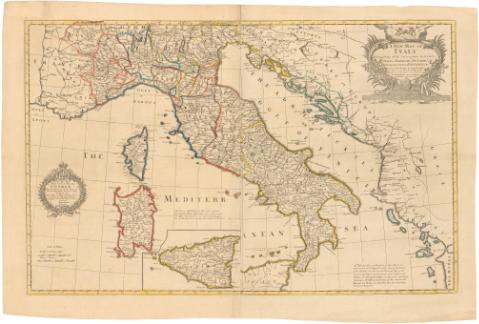
Title: A New Map of Italy : Distinguishing all the Sovereingties in it Wether States, Kingdoms, Dutchies, principalities, Republicks etc. with the Post Roads, & many Remarks not extant in any Map... / This Map is Most humbly Dedicated by his Majesty's Most Loyal... servant Robert Sayer
Material or type of resouce Area: Escala [ca. 1:1600000], 60 British and Italian miles [= 6,5 cm]
Publication: London : Printed for Robt. Sayer Map & Printseller, at the Golden Buck in Fleet Street, [175-]
Physical description: 1 mapa : col. ; 58,5 x 91 cm en h. de 56,9 x 95,1 cm
Notes: Presenta el mapa y un plano de la isla de Sicilia
Comprende además de Italia, parte de Francia, Grecia, Alemania..
Escala gráfica además de 60 millas de Piamonte [= 7,7 cm]. Coordenadas del meridiano de Londres (E5°25'-E22°35'/N45°50'-N37°06'). Red geográfica de 30' en 30'
Relieve de perfil
Notas sobre la erupción del Vesubio de 163 y los desastres que causó
Título enmarcado en cartela con corona real
En la parte izquierda cartela con escudo y corona enmarcando la dedicatoria
ITL
Materia / lugar / evento: Mapas generales
Volcanes
Catástrofes
Divisiones administrativas
Islas
Fronteras
Siglo XVIII
Córcega
Other authors: Sayer, Robert, 1725-1794
UDC: 912:551.21(45)'1750/1759'
(44 Córcega, isla)
Type of publication:
Maps
Rights:
Préstamo:
Disponible
