Zona de Ceuta : levantamiento aerofotogramétrico


 Maps, plans and nautical charts
Zona de Ceuta : levantamiento aerofotogramétrico (1959)
- España. Ejército del Aire. Centro Cartográfico y Fotográfico
Maps, plans and nautical charts
Zona de Ceuta : levantamiento aerofotogramétrico (1959)
- España. Ejército del Aire. Centro Cartográfico y Fotográfico
 Disponible Holdings
 Section: Maps, plans and nautical charts
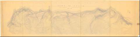
Title: Zona de Ceuta : levantamiento aerofotogramétrico / Servicio Cartográfico y Fotográfico del E.A.
Author: España. Ejército del Aire. Centro Cartográfico y Fotográfico. 1:1.000
[Zona de Ceuta] All editions
Characteristics of the edition: 1959. Español
Material or type of resouce Area: Escala 1:1.000
Publication: 1959
Physical description: 1 plano : copia en ozalid ; 80 x 294 cm
Content type: Imagen cartográfica
Media type: computadora
Carrier type: recurso en línea
Notes: Orientado con flecha
Relieve representado por curvas de nivel
Materia / lugar / evento: Reconocimiento del terreno
Fotogrametría
1959
Ceuta
Genre / form: Mapas topográficos
UDC: (460.37 Ceuta)
Type of publication:
Maps
Rights:
Préstamo:
Disponible
