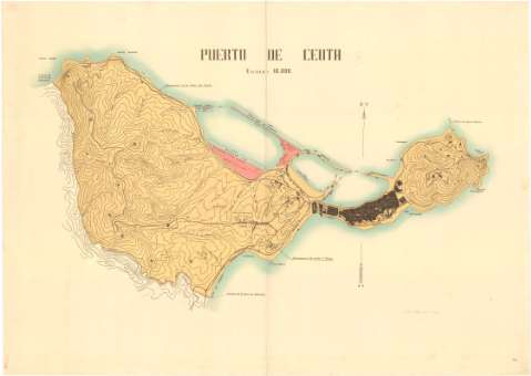
Puerto de Ceuta


Section: Maps, plans and nautical charts
Uniform title: Puerto de Ceuta. 1936. Español. 1:10.000
Title: Puerto de Ceuta
Material or type of resouce Area: Escala 1:10.000
Publication: Madrid : Industria Gráfica Martín, 1936
Physical description: 1 plano : lit., col. ; 81 x 112 cm
Content type: Imagen cartográfica
Media type: computadora
Carrier type: recurso en línea
Notes: Orientado con flecha
Relieve representado por curvas de nivel
Indica relieve; hidrografía; accidentes costeros; vías de comunicación; límites de la zona de soberanía; ubicación de la ciudad con distintas instalaciones militares y el puerto, con mediciones detalladas de los diques construidos y por construir, señalando las zonas destinadas a futuras necesidades, a mercancias en trasbordo, a instalaciones de petroleos y la zona para vender en parcelas
Fecha de publicación tomada de una anotación en el plano
Materia / lugar / evento: Divisiones administrativas
Puertos marítimos
1936
Ceuta
Marruecos (Protectorado Español)
Genre / form: Planos de población
Other authors: Gráficas Martín
UDC: (460.37 Ceuta)
Type of publication:
 Maps
Maps
Rights:
Préstamo:
 Disponible
