Alhucemas : Zona Oriental


 Maps, plans and nautical charts
Alhucemas : Zona Oriental (1924?)
- España. Comisión Geográfica de Marruecos
Maps, plans and nautical charts
Alhucemas : Zona Oriental (1924?)
- España. Comisión Geográfica de Marruecos
 Disponible Holdings
 Section: Maps, plans and nautical charts
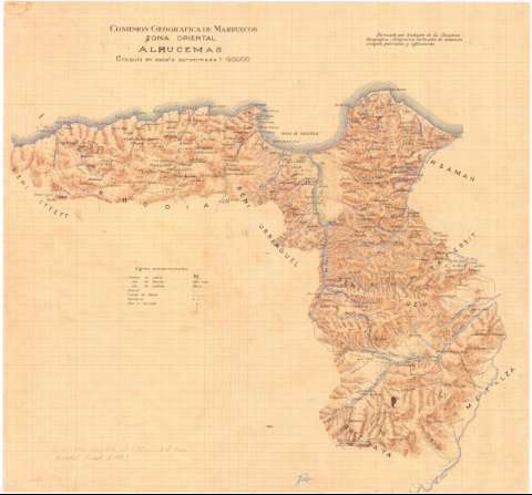
Title: Alhucemas : Zona Oriental / Comisión Geográfica de Marruecos
Author: España. Comisión Geográfica de Marruecos. 1:150.000
[Alhucemas] All editions
Characteristics of the edition: 192-. Español
Material or type of resouce Area: Escala aproximada 1:150.000
Publication: [1924?]
Physical description: 1 mapa : ms., col., en papel milimetrado ; 57 x 61 cm
Content type: Imagen cartográfica
Media type: computadora
Carrier type: recurso en línea
Notes: En el ángulo superior derecho: "Formado con trabajos de la Comisión Geográfica, itinerarios verticales de aviación, croquis parciales y referencias"
Destaca especialmente la representación del relieve y la red hidrográfica
Tabla de signos convencionales para indicar: nombres de cabilas, facciones, poblados, caminos, límites de kábila, santuarios, zocos y mercados
En el ángulo inferior izquierdo: "Sirvió para ampliar el 1:150.000 de la Zona Oriental, tirada de 1925"
Fecha deducida de la anotación mencionada
Manuscrito a plumilla en tintas azul, negra, sepia y carmín
Materia / lugar / evento: Límites territoriales
Divisiones administrativas
Guerra de Marruecos
1925
Alhucemas (Provincia)
Genre / form: Mapas generales
Manuscritos
UDC: (64 Alhucemas, provincia)
Type of publication:
Maps
Rights:
Préstamo:
Disponible
