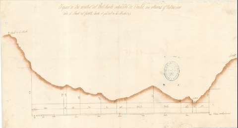
Figura de los montes del Portichuelo entendido de Oriolet...


 Maps, plans and nautical charts
Figura de los montes del Portichuelo entendido de Oriolet, sus alturas y Distancias desde el Monte del Castillo,... (18--?)
Maps, plans and nautical charts
Figura de los montes del Portichuelo entendido de Oriolet, sus alturas y Distancias desde el Monte del Castillo,... (18--?)
 Disponible Holdings
 Section: Maps, plans and nautical charts
Uniform title: ORIHUELA (Alicante) (Sierra). Mapas físicos. 1:2.024 (18)
Title: Figura de los montes del Portichuelo entendido de Oriolet, sus alturas y Distancias desde el Monte del Castillo, hasta el pie del de la Muela : [de Orihuela]
Material or type of resouce Area: Escala [ca. 1:2.024], 800 Varas valencianas [= 33 cm]
Publication: [18--?]
Physical description: 1 plano : col., montado sobre tela ; 23'9x43'7 cm
Content type: Imagen cartográfica
Media type: computadora
Carrier type: recurso en línea
Notes: Subtítulo tomado del documento SH+2561/A-G-2/2
Manuscrito a plumilla en tinta ocre
Materia / lugar / evento: Agrimensura
S.XIX
Alicante (Provincia)
UDC: 467.33 Orihuela
Type of publication:
Maps
Rights:
Préstamo:
Disponible
