North End of Lake Michigan including Green Bay and the...


 Maps, plans and nautical charts
North End of Lake Michigan including Green Bay and the Straits of Mackinac (1867)
Maps, plans and nautical charts
North End of Lake Michigan including Green Bay and the Straits of Mackinac (1867)
 Disponible Holdings
 Section: Maps, plans and nautical charts
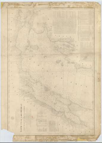
Title: North End of Lake Michigan including Green Bay and the Straits of Mackinac / Projected from a Trigonometrical Survey under the orders of Capt. J.N. Macomb Topl. Engrs. in 1851, 52, 53, 54 and 55 of Capt. G.G. Meade Topl. Engrs. in 1860 & 61 of Col.J.D. Graham Corps of Engrs. in 1862 & 63 and of Col. W.F. Raynolds A.D.C. Maj. of Engr. in 1864, 65 & 66 ; Compiled and reduced for Engraving by J.U. Mueller ; Engraved by W.H. Dougal
Material or type of resouce Area: Escala 1:400000 (O 68°15'30''--O 84°20'30''/N 46°10'30''--N 44°15'30'')
Publication: [Washington] : Bureau of Engineers of the War Department, 1867
Physical description: 1 carta náutica ; 54 x 79 cm
Content type: Imagen cartográfica
Media type: computadora
Carrier type: recurso en línea
Series: (Survey of the Northern and North Western Lakes)
Notes: Escala también dada en formas gráficas de 50000 yardas y 30000 millas legales inglesas. Orientado con tres nudos de treintaidos rumbos
Relieve por normales
Indica sondas batimétricas, veriles y faros, así como las distintas líneas de derrota a seguir para navegar por la zona septentrional del lago
Clave hidrográfica para determinar la calidad del fondo
Tabla referenciales que informan, por un lado los faros existentes, por otro la variación en el nivel del mar y además la variación magnética de varios puntos del area representada
Materia / lugar / evento: Cartas náuticas
Batimetría
Lagos
1866
Other authors: Macomb, J. N
Dougal, W. H
Meade, George G
Graham, James Duncan
Raynolds, W. F
Mueller, J. U
Estados Unidos. War Department. Engineer Bureau
UDC: 774-16
775-18
Type of publication:
Maps
Rights:
Préstamo:
Disponible
