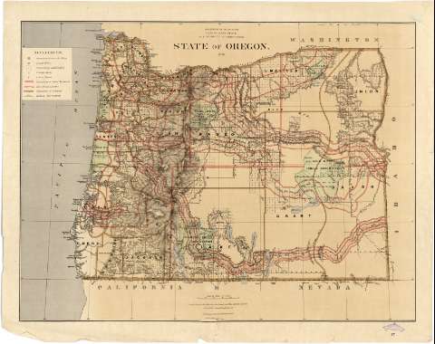
State of Oregon


Section: Maps, plans and nautical charts
Title: State of Oregon / Department of the Interior, General Land Office, S.S. Burdett, Commissioner ; compiled from the official Records of the General Land Office and other sources by C. Roeser, Principal Draguhtsman G.L.O.
Material or type of resouce Area: Escala [1:950400 ; proy. cónica equidistante] (O 125°00'--O 116°06'/ N 46°38'--N 42°00')
Publication: N.Y. [i.e. New York] : Photo lith & print. by Julius Bien 16 & 18 Park Place..., 1876
Physical description: 1 mapa : col. ; 61 x 80 cm
Content type: Imagen cartográfica
Media type: computadora
Carrier type: recurso en línea
Notes: En : "Geographical and Political Atlas of the States and Territories of the United States of America : in wich the Public Land Surveys are now in operation". Hoja 17
Escala nominal de 15 millas por pulgada y gráfica de 50 millas [= 8'5 cm]. Red geográfica de 1° en 1°
Orografía por normales
Sobre el mapa figura trazada una retícula, marcadas con números romanos tanto las abcisas como las ordenadas que parece ser un sistema de localización de aquellos municipios sobre los que se han realizado mediciones catastrales
Señala los territorios que constituyen reservas indias, especificándose la fecha y referencia legal de los tratados por los cuales fueron establecidas
Tabla de signos convencionales empleados para indicar : la situación de las llamadas "Surveyor General's Office" y "Land Office", capitales de condado, límites entre éstos últimos, líneas ferroviarias, etc
Impreso en varios colores
Procede de la colección de Manuel Rico y Sinobas
Materia / lugar / evento: Divisiones administrativas
Mapas generales
Municipios
Poblaciones indígenas
1876
Other authors: Burdett, S.S
Bien, Julius, 1826-1909
Roeser, C
Estados Unidos. Department of the Interior
Estados Unidos. General Land Office
UDC: 912:397(795-28)"1876"
795
Type of publication:
 Maps
Maps
Rights:
Préstamo:
 Disponible
