State of Louisiana


Section: Maps, plans and nautical charts
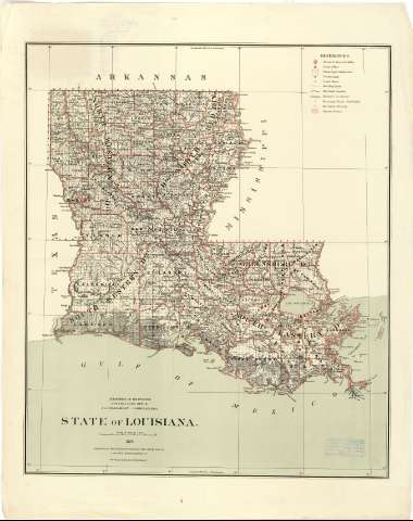
Title: State of Louisiana / Department of the Interior, General Land Office, J.A. Williamson, Commissioner; Commpiled from the official Records of the General Land Office and other sources by C. Roeser, principal dranghtsman G.L.O.
Material or type of resouce Area: Escala [1:887040 ; proy. cónica equidistante] (O 94°--O 89°/N 33°--N 28°)
Publication: N.Y.[i.e. New York] : Photo lith & print by Julius Bien 16 & 18 Park Place, 1879
Physical description: 1 mapa : col. ; 73 x 62 cm
Content type: Imagen cartográfica
Media type: computadora
Carrier type: recurso en línea
Notes: Escala nominal de 14 millas pulgada y gráfica de 50 millas estatutarias [=9'2 cm]. Coordenadas también referidas al meridiano de Washington (O 17°00'--O 11°42'). Red geográfica de 1° en 1°
Sobre el mapa aparece trazada una retícula, marcadas con números arábigos tanto las abcisas como las ordenadas, que parece ser un sistema de localización de aquellos muninicipios sobre los que se han utilizado mediciones catastrales
Tabla de los signos convencionales para indicar: la situación de las llamadas "Surveyor General's Office" y "Land Office", núcleo de población, destcándose las capitales de condado, límites entre íntimas, líneas ferroviarias y la diferenciación entre los municipios que han sido total o parcialmente divididos y los que han desaparecido
Materia / lugar / evento: Divisiones administrativas
Mapas generales
Municipios
Other authors: Williamson, J.A
Bien, Julius, 1826-1909
Roeser, C
Estados Unidos. Department of the Interior. General Land Office
UDC: 912(763-28)"1878"
763
Type of publication:
 Maps
Maps
Rights:
Préstamo:
 Disponible
