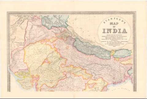
Stanford's. Map of India based on the surveys executed by...


 Maps, plans and nautical charts
Stanford's. Map of India based on the surveys executed by... the East India Company... showing the latest... (1857)
Maps, plans and nautical charts
Stanford's. Map of India based on the surveys executed by... the East India Company... showing the latest... (1857)
 Disponible Holdings
 Section: Maps, plans and nautical charts
Uniform title: India. Colonias. 1:2000000 (1857)
Title: Stanford's. Map of India based on the surveys executed by... the East India Company... showing the latest territorial acquisitions of the British Empire and the independent and protected states Rail ways, Canals, & C.
Material or type of resouce Area: Escala [ca. 1:2000000], 200 English Miles [= 14,7 cm] ; [proyec. cónica] (E66°10'-E93°40'/N34°30'-N6°05')
Publication: London : Edward Stanford, 6, charing Cross, 1857 (Vincent Brooks imp.)
Physical description: 1 mapa en 2 h. : col. ; 179x134,3 cm en h. de 91,7x134, 3 cm
Content type: Imagen cartográfica
Media type: computadora
Carrier type: recurso en línea
Notes: Presenta 1 mapa de la peninsula de Indochina
Escalas gráficas de 50 French Leagues [= 10 cm] y 80 Indian los [= 10 cm]. Orientado con lis. Red geográfica de 1° en 1°
Relieve representado por normales
Tabla de signos convencionales para indicar las lineas ferroviarias, oficinas de correos estaciones militares etc.
Nota relativa a la cronologia de las adquisiciones del imperio británico y la distancias y orientación desde Madrás, Bombay y Calcuta y altos cargos dependientes de Gran Bretaña
Sello en seco del Cuerpo de Estado Mayor. Depósito de la Guerra
Other authors: Stanford, Edward
Brooks, Vincent
UDC: 912:[325.45:625.1:626.1](540)'1857'
(548.7)
Type of publication:
Maps
Rights:
Préstamo:
Disponible
