Jemen [und] Hadramant : versuch einer darstellung...


 Maps, plans and nautical charts
Jemen [und] Hadramant : versuch einer darstellung vonglucklichen oder sudostlichen Arabien zu C. Ritter's Erdkunde... (1846)
Maps, plans and nautical charts
Jemen [und] Hadramant : versuch einer darstellung vonglucklichen oder sudostlichen Arabien zu C. Ritter's Erdkunde... (1846)
 Disponible Holdings
 Section: Maps, plans and nautical charts
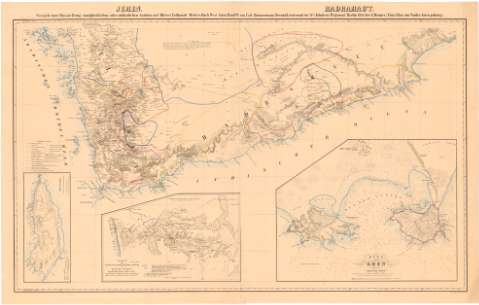
Title: Jemen [und] Hadramant : versuch einer darstellung vonglucklichen oder sudostlichen Arabien zu C. Ritter's Erdkunde (Drittes buch west Asien Band VI) / von Carl Zimmermann, secud lientenant im 21ten. Infanterie Regiment
Material or type of resouce Area: 1:1000000
Publication: Berlin : G. Reimer, 1846 (H. Delius)
Physical description: 1 mapa : col. ; 57,1 x 94,5 cm en h. de 63,3 x 100 cm, pleg. en 63,3 x 51,3 cm
Content type: Imagen cartográfica
Media type: computadora
Carrier type: recurso en línea
Notes: En: Atlas von Vorder Asien gehoring"
Proyec. cónica. Coordenadas referidas al meridiano de París (E 38°50'-E 51°10'/N 17°10'-N 10°). Red geográfica de 1 en 1 grado
Relieve representado por sombreado
Tabla de signos convencionales para indicar las principales expediciones
Inserta: "Socotara. [Ca. 1:600000] ; "Karte des Landstrichs zwischen dsjid da und Tayf in Hedschas Arabien...". [Ca. 1:800000] ; "Plan von Aden und des umliegenden Landes". [Ca. 1:300000]
Materia / lugar / evento: Mapas generales
Expediciones
Batimetría
Penínsulas
Siglo XVIII
S.XIX
Yemen
Omán
Asia
Arabia
Other authors: Zimmermann, Carl
Delius, Hermann
Reimer, G
UDC: 912:[910.4:551.46](53-13)'1712/1845'
(534)
(535)
Type of publication:
Maps
Rights:
Préstamo:
Disponible
