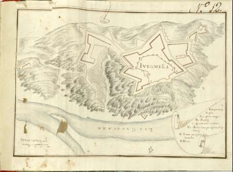
Iuromeña]


Section: Maps, plans and nautical charts
Uniform title: JUROMENHA (Portugal). Fortificaciones (180). 1:1900
Title: Iuromeña]
Material or type of resouce Area: Escala [ca. 1:1900], 100 De varas castillanas [= 4,4 cm]
Publication: [180- ?]
Physical description: 1 plano : ms., col. ; 24,2x36,6 cm en h. de 29,4x41 cm
Content type: Imagen cartográfica
Media type: computadora
Carrier type: recurso en línea
Notes: En : Atlas de fortificaciones del Reino de Portugal y de Extremadura
Título propio redactado a partir del contenido del documento
Manuscrito firmado y rubricado ilegible
Manuscrito a plumilla en tinta negra e iluminado a la acuarela en gris, azul, amarillo y siena
Relieve representado por sombreado
Filigrana : con anagrama de escudo
Relación de las puertas, cuartel, castillo y pozo indicados por clave alfabética
En el ángulo superior derecho : N. 12
Relación de claves enmarcada en cartela
En : Atlas de fortificaciones del Reino de Portugal y de Extremadura]
UDC: 912:[623.2:728.81](469 Juromenha)'1800/1809'
469 Juromenha
Type of publication:
 Maps
Maps
Rights:
Préstamo:
 Disponible
