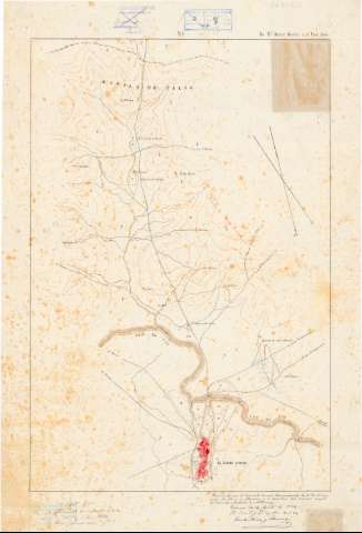
Itinerario] De El Kazar Quebir á el Ued Sebú


 Disponible Holdings
 Section: Maps, plans and nautical charts
Uniform title: Marruecos. Itinerarios (1885). 1:20000
Title: Itinerario] De El Kazar Quebir á el Ued Sebú
Material or type of resouce Area: Escala [ca. 1:20000]
Publication: [1885 ?]
Physical description: 1 mapa en 4 h. : ms., col. ; 70,7x47,9 cm
Content type: Imagen cartográfica
Media type: computadora
Carrier type: recurso en línea
Notes: Comprende parte de las provincias de Tetuan y Kenitra
Manuscrito a plumilla en tinta negra, azul, siena y rojo
Datos matemáticos tomados del Catálogo del SG : 'Mapas de Marruecos'. 1974, p. 95
Orientado con flecha. Indica ángulo de declinación magnética
Relieve representado por curvas de configuración
Clave alfabética para indicar los tipos de vegetación
Manuscrito sobre tela para planos
En el margen superior, numeración de las hojas
Copia del original fechado en Tetuán 16 agosto 1884 con signa SG+ArQ-T.8-C.3-95
Materia / lugar / evento: Itinerarios
Divisiones administrativas
Planos de población
1885
Alcazarquivir
Other authors: Alvarez y Ardanuy, Eduardo, 1849-
Jáudenes, Ramón
UDC: 912:656.02(64-17)'1885'
912:314(64 Alcazarquivir)'1885'(084.3)
(64 Alcazarquivir)
(282.26 Ued Sebú)
Type of publication:
 Maps
Maps
Rights:
Préstamo:
Disponible
