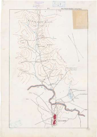
Itinerario] De El Kazar Quebir á el Ued Sebú


 Disponible Holdings
 Section: Maps, plans and nautical charts
Uniform title: Marruecos. Itinerarios (1884). 1:20000
Title: Itinerario] De El Kazar Quebir á el Ued Sebú / Reconocido por el Teniente Coronel Comandante de E.M. D. Ramón Jardenes y Alvarez, y el Capitan del mismo cuerpo D. Eduardo Alvarez y Ardanuy
Material or type of resouce Area: Escala [ca. 1:20000]
Publication: 1884 agosto 16
Physical description: 1 mapa en 4 h. : ms., col. ; 70,7x47,9 cm
Content type: Imagen cartográfica
Media type: computadora
Carrier type: recurso en línea
Notes: Comprende parte de las provincias de Tetuan y Kenitra
'Visto Bueno' El Corl. T.C. Comandante de E.M. Francisco Galbis y Abella
Manuscrito firmado, rubricado y fechado en Tetuán
A plumilla en tinta azul, negra, siena y roja
Datos matemáticos tomados del Catálogo del SG : 'Mapas de Marruecos'. 1974 p. 95
Orientado con flecha. Indica ángulo de declinación magnética
Relieve representado por curvas de configuración
Clave alfabética para indicar los tipos de vegetación
Manuscrito sobre tela para planos
En el margen superior, numeración de las hojas
Acompañado de una hoja manuscrita 'Itinerarios descriptivos del Imperio de Marruecos de el Karar Kuebir a el Ved Sebú. Distancias de los puntos prales al origen. Descripción topográfica. Año 1884, p. 85. n 8'
En carpeta de cartón
Se dispone además de copia con signo SG+ArQ-T.8-C.3-95 bis
Materia / lugar / evento: Itinerarios
Divisiones administrativas
Planos de población
1884
Alcazarquivir
Other authors: Alvarez y Ardanuy, Eduardo, 1849-
Jáudenes, Ramón
UDC: 912:656.02(64-17)'1884'
912:314(64 Alcazarquivir)'1884'(084.3)
(282.26 Ued Sebú)
Type of publication:
 Maps
Maps
Rights:
Préstamo:
Disponible
