Gibraltar


Section: Maps, plans and nautical charts
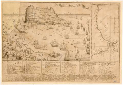
Title: Gibraltar
Material or type of resouce Area: Escala indeterminada
Publication: [Madrid : s.n., 1782-1785?]
Physical description: 1 vista : montado sobre tela ; 23,5 x 34,9 cm en h. de 33,4 x 48,6 cm
Notes: Relación de los principales fortificaciones, "parte más eminente del Monte", arsenales, trincheras, muelles y "Division de Términos entre España y dicha plaza" indicada por clave numérica
Leyenda explicativa de contenido histórico de la ciudad
Indica núcleos de población, campamentos militares y soldados en perspectiva y líneas de ángulo de tiro
Representación de varios barcos en el mar
Inserta: Plano del Estrecho de Gibraltar que presenta la costa desde Rota a Motril. Escala [ca. 1:2000000]
Procede de la "Colección Rico y Sinobas", n. 70
Reproducción fotográfica sobre papel
Materia / lugar / evento: Fortificaciones
Asedios
Perspectivas de costas
Combate naval
Cañoneros
Artillería de campaña
Bahías
Siglo XVIII
Gibraltar
Cádiz (Provincia)
Andalucía
UDC: (460.355 Algeciras)
Type of publication:
 Maps
Maps
Préstamo:
 Disponible
