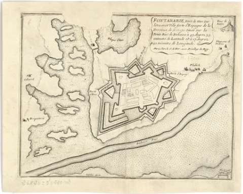
Fontarabie : Port de mer sur l'Ocean et Ville forte...


 Maps, plans and nautical charts
Fontarabie : Port de mer sur l'Ocean et Ville forte d'Espagne de la Province de Biscaye sur la Petite Riu. de... (1715?)
Maps, plans and nautical charts
Fontarabie : Port de mer sur l'Ocean et Ville forte d'Espagne de la Province de Biscaye sur la Petite Riu. de... (1715?)
 Disponible Holdings
 Section: Maps, plans and nautical charts
Uniform title: FUENTERRABíA (Guipúzcoa). Planos de población. 1:3.000 (1715?)
Title: Fontarabie : Port de mer sur l'Ocean et Ville forte d'Espagne de la Province de Biscaye sur la Petite Riu. de Bidasoa a 43 degrez 35 minutes de Latitude et a 17 degrez 50 minutes de Longitude / Infelin fecit
Material or type of resouce Area: Escala [ca. 1:30000]
Publication: A Paris : Chez le Sr. de Fer avec Plivilege du Roy, [1715?]
Physical description: 1 mapa : montado sobre tela ; 17 x 23 cm
Content type: Imagen cartográfica
Media type: computadora
Carrier type: recurso en línea
Notes: Fecha tomada del catálogo del SGE: "Región Vasco-Navarra. Provincia de Guipúzcoa. Siglos XVI a XIX". 1969, p. 240
Escala hallada por comparación con otros documentos de características similares
Presenta el plano de la ciudad fortificada y la perspectiva de alguna edificaciones de sus alrededores
Materia / lugar / evento: Planos de población
Fortificaciones
1715
Guipúzcoa
País Vasco
Other authors: Fer, Nicolas de, 1646-1720
Infelin
UDC: 912:[314(084.3)]:623.1(466.212)"1715"
466.212 Fuenterrabía
Type of publication:
Maps
Rights:
Préstamo:
Disponible
