Der Sudliche Theil des Ober Saechischen - Kreises : der...


 Maps, plans and nautical charts
Der Sudliche Theil des Ober Saechischen - Kreises : der Chur und Furstl : Sachsisele und andere hieher gehorige... (1783)
Maps, plans and nautical charts
Der Sudliche Theil des Ober Saechischen - Kreises : der Chur und Furstl : Sachsisele und andere hieher gehorige... (1783)
 Disponible Holdings
 Section: Maps, plans and nautical charts
Uniform title: Alemania. Mapas generales (1783). 1:690000
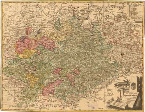
Title: Der Sudliche Theil des Ober Saechischen - Kreises : der Chur und Furstl : Sachsisele und andere hieher gehorige Lander vorftellend / aufs neue enbrorfen von F.L. Gussefeld
Material or type of resouce Area: [Ca. 1:690000], 3 Geographal. Meilen 15-1 [= 3,2 cm] ; [proyec. cónica]
Publication: Nurnberg : herausgegeben von den Homaennischen Erben, 1783
Physical description: 1 mapa : col. ; 43,7 x 56,4 cm
Content type: Imagen cartográfica
Media type: computadora
Carrier type: recurso en línea
Notes: Presenta la zona de Sajonia
Escalas gráficas de 3 Grosse Deutl. M. 12-1 [= 4 cm] y 6 Pauthen [= 3,2 cm]. Coordenadas referidas al meridiano de París (E 27 35'-E 32 55'/N 52 35'-N 50 00'). Red geográfica de 30' en 30'
Relieve representado por sombreado
Tabla de signos convencionales para indicar poblados, trincheras, castillos, monasterios y clave alfabética para indicar abadías, condados, reinos, etc
Indica divisiones administrativas en color
Tabla de signos convencionales en pergaminos, título, mención de responsabilidad y escalas en elementos arquitectónicos de edificio de la época y escudo de armas
Procede de la "Colección Rico y Sinobas"
Materia / lugar / evento: Mapas generales
Divisiones administrativas
1783
Leipzig
Dresde
Sajonia
Alemania
Other authors: Guessefeld, Franz Ludwig
Homann Erben (Firma)
UDC: 912(430-11)'1783'
(430-328 Leipzig)
(430-328 Dresden)
(430-328 Baja Sajonia)
Type of publication:
Maps
Rights:
Préstamo:
Disponible
