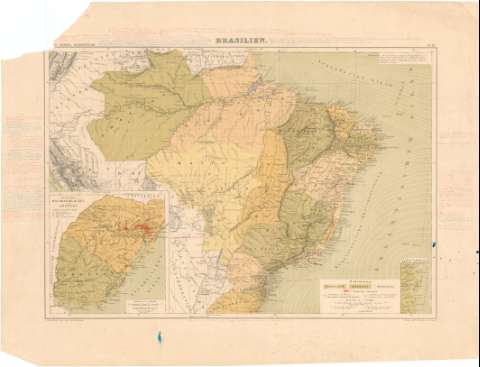
Brasilien


Section: Maps, plans and nautical charts
Uniform title: Brasil. Mapas generales. 1:12900000 (1871?)
Title: Brasilien / F. A. Brockhaus' Geogi-artist. Anstalt, Leipzig
Material or type of resouce Area: Escala 1:12900000 ; [proy. Guillermo Postel Meridiana] (O 77°--O 29°/N 4°--S 30°)
Publication: Leipzig : Verlag von. F.A. Brockhaus, [1871?]
Physical description: 1 mapa : col. ; 31 x 44 cm
Content type: Imagen cartográfica
Media type: computadora
Carrier type: recurso en línea
Notes: Fecha de publicación tomado del "Indice de mapas y planos históricos de América" del SGE., 1974
Escala también dada en forma gráfica, de 100 millas germanas de 15 al grado [= 5'7 cm], 60 leguas portuguesas de 17'93 al grado [= 2'9 cm] y 70 leguas españolas de 20 al grado [= 3 cm]. Coordenadas también referidas al meridiano de París (O 80°--O 30°/N 4°--N 30°). Red geográfica de 10° en 10°
Relieve por normales
Lineas concéntricas para representar las corrientes del Atlántico
Destacadas en rojo las colonias alemanas y en diversos colores los estados que conforman la república de Brasil
Inserta : "Die Provinz Rio Grande do Sul und Uruguay".- Escala 1:6900000, y "Theil der Küste von Santa Catharina".- Escala 1:3400000
Hoja suelta, que pertenece al "Henry Lange's Hand-atlas". N° 26
Notas manuscritas en los márgenes sobre distancias, lugar de manuscrito de varios ríos, navegables, etc.
Materia / lugar / evento: Mapas generales
Divisiones administrativas
Colonias
Other authors: Brockhaus, F.A
UDC: 912:325.45(81-41)"1871"
81
Type of publication:
 Maps
Maps
Rights:
Préstamo:
 Disponible
