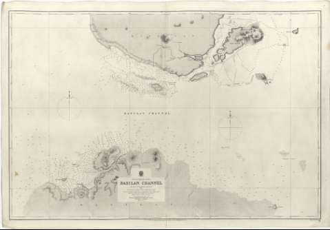
Basilan Channel


Section: Maps, plans and nautical charts
Title: Basilan Channel / surveyed by Capt. Sir Edward Belcher, R.N. C.B. 1847 ; engraved J. & C. WalKer
Material or type of resouce Area: Escala 1:73000 ; [proyec. Mercator] (E 121°45'25''-E 122°23'25''/N 7°01'19''-N 6°36'30")
Publication: London : Published at the Admiralty..., under the Superintendence of Captn. G.H. Richards, R.N. Hydrographer, Feby. 1866
Physical description: 1 carta náutica ; 65 x 97 cm
Content type: Imagen cartográfica
Media type: computadora
Carrier type: recurso en línea
Series: (Sulu Sea Phillipine Islands)
Notes: Presenta además las islas de Sacol, Malanipa, Malamauí, Tulnalutan y Tictiuan
Red geográfica de 10' en 10'. Orientado con dos gráficos de declinación magnética con estrella
Relieve representado mediante normales y puntos acotados
Indica sondas batimétricas, veriles, bajos, fondeaderos y calidad del fondo indicada por clave alfabética
Notas acerca de los mapas que han servido de base para la formación de este (de 1852 y 1862), la variación magnética y las sondas
Sello impreso del "Hidrographic Office G.H.R."
Materia / lugar / evento: Cartas náuticas
Islas
Estrechos
Canales
Fondeaderos
1847
Mindanao
Basilán
Filipinas
Other authors: Belcher, Edward
Gran Bretaña. Hydrographic Department
J. & C. Walker
UDC: 599 Basilán, estrecho
Type of publication:
 Maps
Maps
Rights:
Préstamo:
 Disponible
