A New Survey of the Coast of Africa from Senegal and Cape...


 Maps, plans and nautical charts
A New Survey of the Coast of Africa from Senegal and Cape Verd to Cape Verd to Cape St. Ann : Digested from the... (12th May 1794)
Maps, plans and nautical charts
A New Survey of the Coast of Africa from Senegal and Cape Verd to Cape Verd to Cape St. Ann : Digested from the... (12th May 1794)
 Disponible Holdings
 Section: Maps, plans and nautical charts
Uniform title: AFRICA. Cartas náuticas. 1:1000000 (1794)
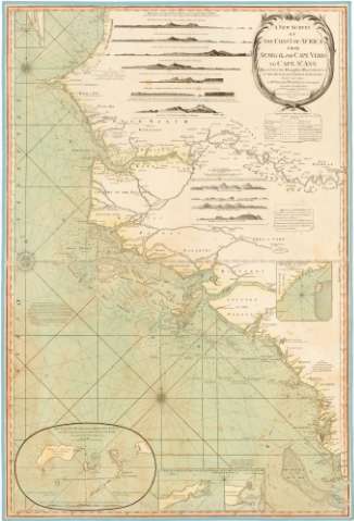
Title: A New Survey of the Coast of Africa from Senegal and Cape Verd to Cape Verd to Cape St. Ann : Digested from the Draughts, Observations & Ca. of the British and French Navigators / Chiefly from those of Mr. William Woodville..
Material or type of resouce Area: [Ca. 1:1000000]
Publication: London : Published by Laurie & Whittle, 53 Fleet Street, 12th May 1794
Physical description: 1 carta náutica : col., montada sobre tela ; 101 x 68 cm, pleg. en 50,8 x 68 cm
Content type: Imagen cartográfica
Media type: computadora
Carrier type: recurso en línea
Notes: Presenta además once perfiles
Escala hallada a partir de un grado de latitud [= 10,8 cm]. Coordenadas referidas al meridiano de Londres (O 18°-O 14°/N 16°-N 7°). Orientada con lis en rosa de los vientos
Relieve de perfil
Indica veriles, bajos, fondeaderos y sondas batimétricas
Tabla de signos convencionales para indicar vientos y corrientes marinas
Nota sobre observaciones astronómicas
Título enmarcado en circulo con hojas de palmeras
Inserta: "The Volcanic Islands named ilhas dos Idolos". Escala [ca. 1:400000], 4 millas nauticas [= 6 cm] ; "A Sketch of the East Point of Bananas Islands and the East and of plantain Island". Escala [ca. 1:200000], 1 milla [= 2,7 cm] ; "The Road of Bissao". Escala [ca. 1:200000], 2 millas [= 5 cm]
Other authors: Woodville, William
Robert Laurie and James Whittle
UDC: 912:551.46(6-15)'1744'
6-15
Type of publication:
Maps
Rights:
Préstamo:
Disponible
