Die Flussgebiete des Binue, Alt Colabar & Camerun in West...


 Maps, plans and nautical charts
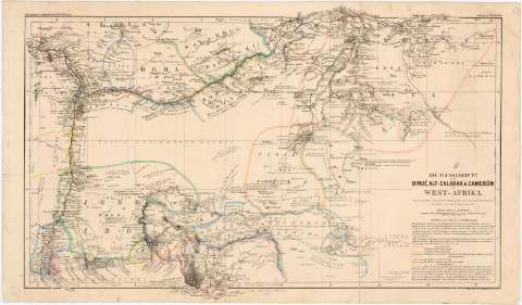
Die Flussgebiete des Binue, Alt Colabar & Camerun in West-Afrika (1863)
Maps, plans and nautical charts
Die Flussgebiete des Binue, Alt Colabar & Camerun in West-Afrika (1863)
 Disponible Holdings
 Section: Maps, plans and nautical charts
Uniform title: AFRICA. NO. Mapas generales. 1:2500000 (1863)
Title: Die Flussgebiete des Binue, Alt Colabar & Camerun in West-Afrika / bear beitet von B. Hassenstein
Material or type of resouce Area: 1:2500000 (E 6°0'-E 15°10'/N 8°45'-N 4°0')
Publication: Gotha : Justus Perthes, 1863 (Lith Arist J.C. Hellfarthin)
Physical description: 1 mapa : col., montado sobre tela ; 24,5 x 43 cm en h. de 27,5 x 47 cm
Content type: Imagen cartográfica
Media type: computadora
Carrier type: recurso en línea
Notes: Escala gráfica de 15 millas alemanas de 15 al grado [= 6 cm]
Relieve representado por normales
Tabla de signos convencionales para indicar las rutas en toda esta zona
Other authors: Hassenstein, Bruno
Perthes, Justus, 1749-1816
Hellfarth, C
UDC: 912:(6-16)'1863'
6,16
Type of publication:
Maps
Rights:
Préstamo:
Disponible
