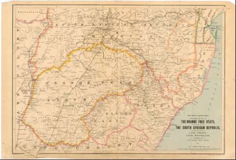
Stanford's new map of the Orange free state, the southern...


 Maps, plans and nautical charts
Stanford's new map of the Orange free state, the southern part of the south African Republic, the northern frontier... (1899)
Maps, plans and nautical charts
Stanford's new map of the Orange free state, the southern part of the south African Republic, the northern frontier... (1899)
 Disponible Holdings
 Section: Maps, plans and nautical charts
Uniform title: AFRICA. SE. Mapas generales. 1:1000000 (1899)
Title: Stanford's new map of the Orange free state, the southern part of the south African Republic, the northern frontier of Cape Colony, Natal, Basutoland, and Delagoa Bay in Portuguese East Africa : the Crisis in South Africa / Stanford's Geographical Establishment...
Material or type of resouce Area: 1:1000000 ; [proyec. sinusoidal]
Publication: London : Published by Edward Stanford, 26 & 27, Cock spur Street, Charing Cross, S.W., 1899
Physical description: 1 mapa : col. ; 68,5 x 101,2 cm
Content type: Imagen cartográfica
Media type: computadora
Carrier type: recurso en línea
Notes: Comprende Swazilandia, Lesotho y parte de Mozambique y Sudáfrica
Coordenadas según el meridiano de Greenwich (E 25 00'-E 2 50'/S 25 30'-S 30 37'). Red geográfica de 2 en 2
Nota relativa a las alturas
Materia / lugar / evento: Mapas generales
Colonias
Topónimos antiguos
1899
Mozambique
Sudáfrica
África
Other authors: Stanford, Edward
Stanford's Geographical Establishment (Londres)
UDC: (6-14)
Type of publication:
Maps
Rights:
Préstamo:
Disponible
