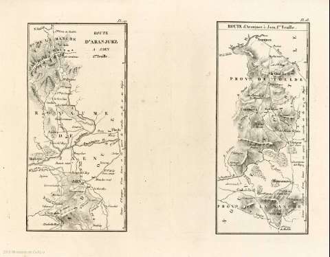
Route d'Aranjuez à Jaen : 2me. feuille [carte d'itineraires]


 Maps, plans and nautical charts
Route d'Aranjuez à Jaen : 2me. feuille [carte d'itineraires] (1834)
Maps, plans and nautical charts
Route d'Aranjuez à Jaen : 2me. feuille [carte d'itineraires] (1834)
 Disponible Holdings
 Section: Maps, plans and nautical charts
Uniform title: Aranjuez (Madrid). Itinerarios. [1834]. 1:802.825
Title: Route d'Aranjuez à Jaen : 2me. feuille [carte d'itineraires]
Material or type of resouce Area: Escala [ca. 1:802.825], 25 leguas d'Espagne d'une heure et un quart de marche ou 20 au dégré [= 17,3 cm]
Publication: [París] : [imprimerie de Firmin Didot fréres, rue Jacob, n. 24], [1834]
Physical description: 1 mapa ; 19 x 18 cm en h. de 35 x 26 cm
Content type: Imagen cartográfica
Media type: computadora
Carrier type: recurso en línea
Notes: Relieve representado por sombreado y sombreado
Hidrografía y vias de comunicaión
Copia digital . España : Ministerio de Cultura y Deporte. Subdirección General de Coordinación Bibliotecaria, 2010
Route d'Aranjuez á Jaen 1er. feuille
Other titles: En: Itinéraire descriptif de l'Espagne : troisiéme édition. - Paris : imprimerie de Firmin Didot fréres, rue Jacob, n 24, 1834. - Pl. 19
Materia / lugar / evento: Mapas itinerarios
Distancias
Jaén
Andalucía
Other authors: Firmin-Didot
Related titles: Jaén (Provincia). Iinerarios ([1834]). 1:802.825
UDC: (460.352)
Type of publication:
Maps
Rights:
