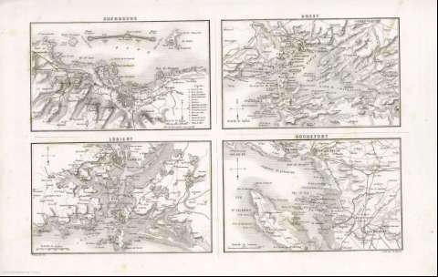
Lorient : [carte de campagne]


 Disponible Holdings
 Section: Maps, plans and nautical charts
Title: Lorient : [carte de campagne] / E. Testarode del ; gravé par Beaurain
Author: Testarode, E
Material or type of resouce Area: Escala 1:80000
Publication: [París] : [Furne, Jouvet et Cie], 1870]
Physical description: 1 mapa ; 11x17 cm, en h. de 28x43 cm
Content type: Imagen cartográfica
Media type: computadora
Carrier type: recurso en línea
Notes: Relieve; sombreado
Orientado con flecha
Copia digital . España : Ministerio de Cultura y Deporte. Subdirección General de Coordinación Bibliotecaria, 2010
Materia / lugar / evento: Mapas militares
Geografía militar
Fortalezas militares
Puertos
Radas
Lorient (Francia)(Bretaña)
Cherbourg (Francia)
Brest (Francia)
Rochefort (Francia)(Charente Maritimo)
Other authors: Beaurain
Furne, Jouvet et Cie
Related titles: Bretaña (Francia). Mapas militares. [1870]. Ca. 1:80.000
UDC: 912:355]:[355.47:623.1:627.22:627.231](44 Bretaña)'1870'
912:314(44 Lourent)(084.3)
44 Bretaña
Type of publication:
 Maps
Maps
Rights:
