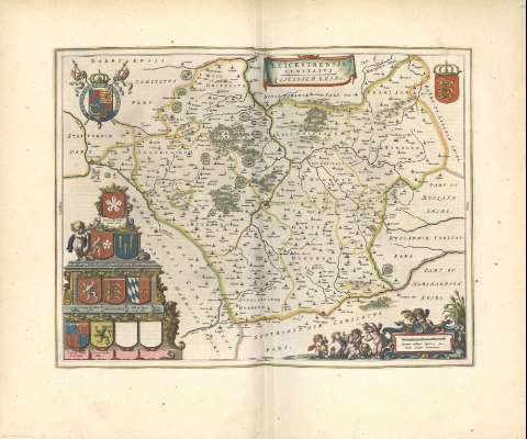
Leicestrensis Comitatus = Leicester shire


Section: Maps, plans and nautical charts
Title: Leicestrensis Comitatus = Leicester shire
Other titles: Leicester shire
Material or type of resouce Area: Escala [ca. 1:150000]
Physical description: 1 mapa : col. ; 38 x 50 cm
Content type: Imagen cartográfica
Media type: computadora
Carrier type: recurso en línea
Notes: Escala gráfica de 4 millas inglesas de las que cuatro hacen una alemana [= 5,1 cm]. Mención nominal de los puntos cardinales
Diferencia con color las líneas divisorias de los hundreds queforman el condado y sus límites, mencionando los colindantes
Adornado con escudos entre los que se encuentran el de la casa real inglesa y el de Inglaterra
Dos cartelas barrocas, una en forma de servilleta, enmarcando el título, la otra con la escala, decorada con angelotes
Toponimia abundante
Hidrografía
Arbolado
Relieve por montes de perfil y sombreado
Núcleos de población destacando los más importantes, lugares y edificios más representativos
Todo el mapa está rodeado por una orla tipográfica a modo de marco
Copia digital. Madrid : Ministerio de Cultura, 2010
Other titles: En: Nuevo Atlas del Reyno de Inglaterra. - Amsterdami : Apud Iohannem Blaeu, 1648. - [Mapa 27]
Materia / lugar / evento: Mapas generales
Divisiones administrativas
1648
Inglaterra
Other authors: Blaeu, Joan, 1596-1673
UDC: 912(410.142)"1648"
(410.142 Leicestershire)
Type of publication:
 Maps
Maps
Préstamo:

 Disponible sólo para consulta en sala
