Sacred Geography adapted to the Old and New Testament


 Maps, plans and nautical charts
Sacred Geography adapted to the Old and New Testament (Ca. 1710-1800)
Maps, plans and nautical charts
Sacred Geography adapted to the Old and New Testament (Ca. 1710-1800)
 Disponible Holdings
 Section: Maps, plans and nautical charts
Uniform title: Oriente Medio. Mapas generales. ca. 1710-1800
Title: Sacred Geography adapted to the Old and New Testament
Material or type of resouce Area: Varias escalas
Publication: London : Robert Sayer, [Ca. 1710-1800]
Physical description: 1 atlas : 4 lám. col. ; 45 x 30 cm
Content type: Imagen cartográfica
Media type: computadora
Carrier type: recurso en línea
Notes: Relieve representado por símbolos
Señala vegetación
Tabla de signos convencionales para indicar núcleos de población de distinta categoría
Indica las divisiones administrativas separadas por colores
Señala los itinerarios seguidos por Jesucristo y los apóstoles
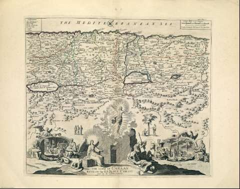
Lám. 1. A Map of the Sacred Geography taken from the Old and New Testament -- Lám. 2. A Map shewing situation of Paradise and Country Inhabited by Patriarches -- Lám. 3.The Land of Canaan, Traveld over by O. S. Jesus Christ and by his Apostles -- Lám. 4. A Map Shewing the most Remarkable Places to which the Apostles Traveld to Preach the Gospel as alfo St. Paul's Voyage to Rome
Copia digital. Madrid : Ministerio de Cultura, 2010
Included records: The Land of Canaan : Traveld over by O. S. Jesus Christ and by his Apostles
A Map of the Sacred Geography taken from the Old and New Testament : containing Most of Then Known Parts of the World and by Whom Peopled
[...] Ver todos los registros incluidos (4)
Materia / lugar / evento: Mapas generales
Mapas históricos
Núcleos de población
Divisiones administrativas
Ríos
Accidentes geográficos
Itinerarios
Geografía bíblica
Judea
Palestina
Tierra Santa
UDC: (33)
Type of publication:
Maps
Préstamo:
 Disponible sólo para consulta en sala
