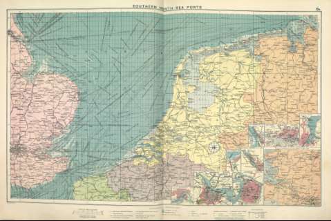
Southern North Sea ports


 Disponible Holdings
 Section: Maps, plans and nautical charts
Title: Southern North Sea ports
Author: Philip, George, 1870-1937
Material or type of resouce Area: Escala 1:1.500.000
Publication: [London] ; [Liverpool] : George Philip & Son, Ltd : The London Geographical Institute : Philip, Son & Nephew, [1922]
Physical description: 1 mapa ; 49 x 73 cm
Content type: Imagen cartográfica
Media type: computadora
Carrier type: recurso en línea
Notes: Copia digital. Madrid : Ministerio de Cultura, 2010
Inserta mapas de: Bremerhaven ; Kiel ; Zeebrugge ; Bremen ; Rotterdam ; Amsterdam ; Antwerp ; Hamburg ; Eastern Continuation of General Map on same scale
Other titles: En: Philip's Mercantile Marine Atlas. - [London] : Edited by George Philip [et al.], 1922. - Mapa 8
Materia / lugar / evento: Puertos
Rutas marítimas - Mapas
Mar del Norte meridional
Genre / form: Cartas náuticas
Other authors: George Philip & Son
Merchant, Shippers, Exported and Ocean Travelles
London Geographical Institute
Related titles: Mar del Norte meridional. Mapas generales. ca. 1922
UDC: (261.26)
Type of publication:
 Maps
Maps
Préstamo:
 Disponible sólo para consulta en sala
