The South East Coast of The Bay of Fundy : from Annapolis...


 Maps, plans and nautical charts
The South East Coast of The Bay of Fundy : from Annapolis Royal, to cape St. Mary, the Bay of St. Mary, Gand-pasage,... (1776)
- Des Barres, Joseph F. W (Joseph Frederick Wallet), 1722-1824
Maps, plans and nautical charts
The South East Coast of The Bay of Fundy : from Annapolis Royal, to cape St. Mary, the Bay of St. Mary, Gand-pasage,... (1776)
- Des Barres, Joseph F. W (Joseph Frederick Wallet), 1722-1824
 Disponible Holdings
 Section: Maps, plans and nautical charts
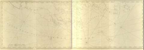
Title: The South East Coast of The Bay of Fundy : from Annapolis Royal, to cape St. Mary, the Bay of St. Mary, Gand-pasage, Petit Passge, & c / J.F.W. Des Barres ; [Tomkins Scriptit, H. Ashby Sculpit]
Material or type of resouce Area: Escala [ca. 1:58325] (O 63°53'--O 63°29'/N 44°07'--N 43°12')
Publication: [London?] : J.F.W. Des Barres, 1776
Physical description: 1 mapa ; 68 x 199 cm, pleg. 80 x 57 cm
Content type: Imagen cartográfica
Media type: computadora
Carrier type: recurso en línea
Notes: The Sea Coast of Nova Scotia, Nº 7
Carta náutica de la parte suroriental de la bahía de Fundy, en la provincia de Nueva Escocia en la que se señalan, además de sus principales accidentes, geográficos; su batimetría de sondas y veriles, calidad de arenas, fondeaderos y duración y altura alzanzada por la marea; todo ello, de la mano de indicadores que se relacionan con el índice que presenta el volumen en su primer mapa
Orientado con nudos de 32 rumbos y lis, dando cuenta del ángulo de declinación magnética
Escala gráfica en millas legales y náuticas inglesas
Título propio tomado del índice que presenta el volumen, de los mapas que contiene
Other titles: En: The Atlantic Neptune. - [London?] : J. F. W. Des Barres, 1774- 1780. - 7
Other authors: Ashby, Harry, 1744-1818
Tomkins, Thomas, 1743-1816
Related titles: Bahía de Fundy (Canadá). Cartas náuticas (1776). 1:58325
UDC: 912:551.46]:551.468(716)"1776"
716
Type of publication:
Maps
Préstamo:
 Disponible sólo para consulta en sala
