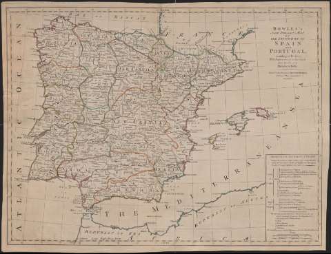
Bowles's new pocket Map of the Kingdoms of Spain and...


 Maps, plans and nautical charts
Bowles's new pocket Map of the Kingdoms of Spain and Portugal : according to De Lisle with improvements on the... (1749)
Maps, plans and nautical charts
Bowles's new pocket Map of the Kingdoms of Spain and Portugal : according to De Lisle with improvements on the... (1749)
 Disponible Holdings
 Section: Maps, plans and nautical charts
Uniform title: España. Mapas generales. 1:2721085 (1749)
Title: Bowles's new pocket Map of the Kingdoms of Spain and Portugal : according to De Lisle with improvements on the coasts from the charts of Michelot & Bellin
Material or type of resouce Area: Escala [ca. 1:2.721.085]. 30 leguas españolas de 17'5 al grado [= 7 cm]
Publication: London : Printed for the Propietor Carrington Bowles, [1749]
Physical description: 1 mapa : col. ; 45 x 59 cm
Content type: Imagen cartográfica
Media type: computadora
Carrier type: recurso en línea
Notes: Coordenadas referidas al meridiano de Hierro. Graduado
Relieve representado por sombreado
Grabado sobre papel
En el ángulo inferior derecho, división por provincias de España y Portugal
Materia / lugar / evento: Mapas generales
Divisiones administrativas
España
Portugal
Other authors: Bowles, Carrington, 1724-1793
UDC: 460
Type of publication:
Maps
Rights:
Préstamo:
Disponible
